Westspit Braddock Bay

Friday, April 17, 2015

Swans on Braddock Bay . . .

Besides the mute or trumpeter swan inhabiting Braddock Bay, one of the few freshwater estuaries on the Great Lakes, there are migrating tundra or arctic swans which swoop down in large numbers in late winter, part of their yearly migration from the south to breeding grounds up north.Emptying into Braddock Bay, Salmon and Buttonwood Creeks drain a huge portion of western Monroe County, as far as the town of Sweden, releasing large amounts of sediment which restores the marshes ringing the bay. Migrating Canada geese, turkey vultures, songbirds, ducks, raptors [hawks] and swans are an essential part of a global ecosystem increasingly threatened by lack of habitat and forage. 


I photographed this trumpeter swan family last summer and was struck by the parents' protectiveness toward their cygnets. You can tell trumpeter from tundra by the orange on the bill of the trumpeter. Tundra swans' bills are all black. If we disregarded, chemically-killed or on other ways altered all the animal and plant 'invasive species' we see, we would have a lot of bare spots everywhere. We humans are also an invasive species as we know from our American history. 

I would hope that we see how genuinely fragile each species is and without invoking 'climate change' which will alter weather and habitat, we make adjustments rather than launching mechanical and chemical campaigns in our most important habitats.

Saturday, April 11, 2015

Great Lakes Commons Charter Declaration

We, the people of the Great Lakes, love and depend upon our waters to sustain our lives, our communities and all life in our ecosystem.

It is therefore with growing alarm that we confront a painful reality – that despite decades of effort the Lakes are more threatened than ever. As people from across the Great Lakes, we find this unacceptable. We cannot stand by while our waters are treated as an expendable and exploitable resource when we know they are a source of life.

Moved by a hope that we can yet create a thriving and life sustaining future for our Lakes, we step forward to take up our responsibility to care for and act on behalf of these waters, our Great Lakes Commons. Seeing that the health of our waters is intertwined with our own health and that of generations yet to come, we are called to assert a deeper connection and more powerful role in the future of our waters.

We hereby set forth the Great Lakes Commons Charter, a living document that affirms and empowers the wisdom and rightful role of the people of the Lakes as stewards of our waters.

This Declaration and the First Principles emerge from the collaborative work of people and communities around the lakes. Together we reflect many walks of life, histories and cultures. At the same time, a single purpose unites us: to transition to a mode of Great Lakes governance by which the waters and all living beings can flourish. 

Towards this end, we affirm:

That the waters of the Great Lakes have sustained the lives of the people and communities in their basin since time immemorial and they should continue to do so in perpetuity.

That the waters, ecosystems, and communities of the Great Lakes are entwined and interdependent. Damage to any of these causes harm to the others.

That the Great Lakes are a gift and a responsibility held in common by the peoples and communities of the Lakes and must be treated as such as to ensure their preservation for coming generations.

That the boundaries of states, provinces and nations crisscross the Lakes but do not divide their natural integrity. All decision-making that impacts the Great Lakes must place the well-being of the bio-region and ecosystem as a whole at the center of consideration.

That the inherent sovereignty and rights of Indigenous peoples as codified in treaties and international agreements must be upheld as foundational to commons governance.

Therefore:

We join our voices in affirming the spirit and necessity of this declaration as the foundation for a renewed relationship and mode of governance for our Great Lakes Commons. We welcome the wisdom, standing and power that this document will accrue over time to shape the future of our Lakes. We invest it with our hopes and commitments to that future and to the future generations who will inherit the legacy of our actions.

In signing this Charter, we embrace our responsibility, individual and collective, to act on behalf of these waters and of future generations.


October 28, 2014 ~ Great Lakes Charter was established. The Charter was initiated and incubated as a project by Minneapolis-based On The Commons. A number of organizations and individuals from the U.S., Canada, and First Nations provided leadership and guidance from early on including:


Wednesday, March 04, 2015

Great Lakes Restoration Initiative funding cut in proposed Federal Budget

The Great Lakes Restoration Initiative funding in 2015-16 Budget proposal has been cut by $50 million.  

NOTE: $1.9 Billion has already been spent

The Federal Budget proposal by the President for 2016 seeks a "modest reduction" in the multi-year program to clean up the Great Lakes.  The spending plan requests $250M for the GLRI, down from the $300M appropriated this year. 

The Great Lakes Restoration Initiative based in Chicago channels federal funding for small projects focusing on ecological challenges such as invasive species, toxic pollution, degraded fish and wildlife habitat, and runoff from farms and cities that causes toxic algae blooms. President Obama created the program after taking office in 2009. About $1.9 billion has been spent on about 2,000 projects region wide.


Sunday, January 25, 2015

What works in restoring rivers, streams, marshes ~ 'Pulse Flow'

Colorado River restoraction ~ photo Erika Nortemann
Think of it as a surge of water.  It's what happens when there's a big rainfall or the snow melts into a river.  The flow increases for a few days or weeks, and then it goes back to normal. Rather than weather, this environmental experiment will be a release of water from a reservoir.  

It is designed to mimic the kind of natural pulse flows that help keep rivers healthy by spreading native plant seeds and creating conditions for those seedlings to grow and thrive ~ Hydrologist Eloise Kendy in nature.org: 
http://www.nature.org/ourinitiatives/regions/northamerica/areas/coloradoriver/colorado-river-pulse-flow-qa-with-eloise-kendy.xml


Wednesday, January 07, 2015

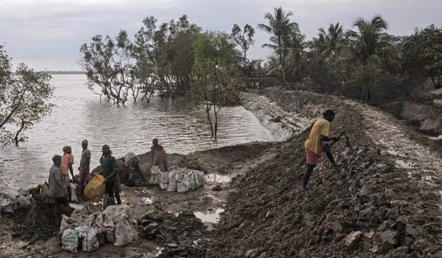
Study: embankments prevent necessary sediment deposit; land subsides in Ganges-Brahmaputra River Delta

Earthen embankments meant to stem tidal flooding 
are preventing  the deposition of sediment 
which is necessary to maintain elevation
A team of scientists from Vanderbilt University has found that what looked like 'sea-level rise' may be something else entirely in a low-lying region of Bangladesh. The deposition of sediment is constantly needed to replenish land and prevent flooding.
"Man-made flood protections, not climate change, are the main culprit in sea-level rise in southwest Bangladesh, according to new research conducted for the U.S. Navy's Office of Naval Research. The report is the first part in a wide-ranging, $7.5 million analysis of environmental stress and human migration scenarios in the low-lying South Asian nation." -- reported in Jan. 7, 2015 Scientific American.
According to a Jan. 8, 2015 article in The Hindu, "Bangladesh’s estuarine islands are sinking, and ironically, this could owe to embankments built to protect them from tidal erosion. Some islands have sunk by as much as 1.5 metres in the last 50 years, says a study published recently in the journal Nature Climate Change." 
"The over 50 large islands in southwest Bangladesh, once forested but now primarily rice growing, were embanked in the 1960s and 1970s to protect them against tidal and storm-surge inundation. But these earthen embankments, while buffering them against floods, have also prevented the deposition of sediment that helps maintain an elevation in this area." 
"The loss of elevation was felt most significantly during the 2009 cyclone Alia when large areas of land were left inundated for up to two years. “Despite sustained human suffering during this time, the newly reconnected landscape received tens of centimetres of tidally deposited sediment, equivalent to decades’ worth of normal sedimentation,” says the paper. Deforestation and a regionally increased tidal range have contributed to the phenomenon, say the researchers from Vanderbilt University, Tennessee, U.S. and Khulna University, Bangladesh. Interestingly, while these islands in the Ganges–Brahmaputra river delta are fast submerging, putting millions of inhabitants at risk of flooding, the neighbouring Sundarbans mangroves are stable from their natural shield of vegetation, the paper adds."  
"Researchers used GPS and a theodolite survey of land elevations at an island called Polder-32 in southwest Bangladesh and compared it with the Sundarbans. They found that the mean elevation of Polder-32 is 1.15 metres lower than Sundarbans." 
"The study therefore implicates 'direct human modification of the environment' and not global sea-level rise as the most important agent of change in the western Ganges Brahmaputra tidal delta plain, says the paper."
“The striking contrast between the tidal inundation patterns of these landscapes highlights the impact of sediment starvation and the historical loss of elevation, which has severely exacerbated the effects of tidal inundation,” notes the paper." 
"However it is possible to recover some of the lost ground, say the authors adding that 'controlled breaching of embankments' can restore elevation and relieve environmental problems. 'The silver lining for Bangladesh and the delta system remains the one billion tons of river sediment that may be effectively dispersed onto the landscape to alleviate elevation deficits. On the basis of our observations, a feasible management strategy from the physical-science perspective may be to systematically breach embankment sections to facilitate sediment delivery and elevation recovery.'”

Tuesday, December 23, 2014

To whom are we accountable?

“The only special interest group I hold myself accountable to is the local taxpayers,” said Monroe County NY Executive Maggie Brooks in a December 2014 letter to NYS politicians and residents of the county stating non-support of "Plan 2014" proposed by the International Joint Commission to adjust Lake Ontario water levels in accordance with hydroelectric, shipping, shoreline erosion and other competing interests.   

Great Blue Heron Braddock Bay NY


I see the problem and I am reminded of the spectre of the October 2012 super-storm Sandy which hit New Jersey, NYC and Long Island.  I remember Monroe County NY Emergency Management sending out a robo-call on my street to evacuate -- the fire trucks announcing it at 3 am -- no one left Manitou Beach Rd.  

As a L. Ontario shoreline resident overlooking the shore [not directly on it], if I were involved in the public information regarding this issue, I would educate and not frighten. 

Take a look at L. Ontario levels: http://www.glerl.noaa.gov/data/now/wlevels/levels.html  
Lake Ontario shorelines are vulnerable, but the likelihood of devastation is minimal. 

The Town of Greece, State and Federal agencies, non-profits, the local environmentalists and others stand to gain if a hyped-up scenario of possible shoreline erosion wins the media battle. There are a lot of $$$ for erosion control and marsh restoration through Homeland Security and GLRI through Army Corps and other private contractors. 

The answer to lake flooding and erosion is to take a step back and consider the entire Great Lakes basin, water levels, precipitation, weather events, etc. over the last century and take a deep breath. From Oswego to Wilson, some homes are knowingly situated on fragile bluffs, cliffs and constantly eroding land, others on more stable shoreline. In days gone by only seasonal cottages primarily dotted the barrier beaches and were located close to the shore.

We often are unable to get good information about hydropower and especially in Canada. Because NYS buys so much Quebec electricity off the grid, it pushes the IJC toward leniency in hydroelectric production on the St. Lawrence. 

Agencies and non-profits, marinas and others are ready to spend $$$ to 'restore' fragile bays and other sensitive areas with concrete break walls. Why? 

Might be that the variable nature of Great Lakes hydrology, hydroelectric production leaves too much room for speculation?  

We could lose the Great Lakes as a water resource entirely.  . . . . perhaps that is what we could remember.

Monday, December 22, 2014

Land under Jakarta subsiding


According the news agency Reuters, cities in Indonesia like Jakarta and the surrounding area called Jabotabek which includes Jakarta, Bogor, Tangerany and Bekasi with a population pushing 25 million are losing the battle against water through subsidence. 

"The problem is particularly acute in Jakarta because most of its millions of residents suck water through wells that tap shallow underground aquifers. 

"Wells also provide about a third of the needs of business and industry, according to city data. 'It’s like swiss cheese underneath,' a World Bank’s representative said. 

'Groundwater extraction is unparalleled for a city of this size. People are digging deeper and deeper, and the ground is collapsing.'  

"The effect is worsened by the sheer weight of Jakarta’s urban sprawl. Economic development in recent decades has transformed the city’s traditional low-rise silhouette into a thickening forest of high-rise towers. The weight of all those buildings crushes the porous ground underneath."  

Annual floods in the rainy season are made worse by burgeoning urban population growth.  Jakarta is considered a 'mega-city' or an 'urban agglomeration.'  As people leave rural areas moving into the city outskirts, the old forests and wetlands around the city disappear. The infrastructure to support the population is nonexistent in many areas. 


The loss of environmentally-sensitive and flood-forgiving land in a city of massive poverty and slums has degraded life and water quality for everyone. 

Monday, December 15, 2014

Building a 'fake beach' east of Braddock Bay L. Ontario

Customized boat launch basin in Lake Forest, Illinois.
Does the Town of Greece want to do this at the far western
end of Edgemere Dr.? Will Great Lakes Restoration Initiative 

fund this which was built by Canadian firm, Baird and Associates?
The Town of Greece has always thought 'big.' Its 94,000 population provides a substantial assessment base and traditionally Republican voting bloc. What does the Town want?  They want $$$.

They want RECREATION even if that means bending science to fit the facts and politically shimmying up to Senator Chuck Schumer [D-NY] for that $9M in US GLRI funding.

What does the IJC support for Braddock Bay?

Look at a prototype designed by Baird and Associates of Ottawa, Ontario which is commissioned by the IJC for this kind of work.  And is funded by US $$$.  Be prepared for this to occur on the eastern side of Braddock Bay with sands constantly being replenished by transporting them from the submerged barrier, the old Manitou Trolley foundation which runs across the entire mouth of the bay.  Yet, it is this old, submerged foundation that keeps the Bay healthy --- take it away, change that hydrology and wave action . . . . turn the Bay into a muck hole with sediment deposition from Salmon and Buttonwood Creeks. 

Tuesday, December 02, 2014

L. Ontario water levels under IJC's "Plan 2014"

Westspit Braddock Bay NY Summer 2014
In plain language, competing interests for water levels on Lake Ontario fight on stage called the "International Joint Commission."  This US-Canadian body has power over water levels due to both the hydro projects and the shipping locks in the St. Lawrence Seaway.  In between are nuclear and coal-fired power plants, sports fisherpeople, boaters, shoreline residents, birders, hunters, environmentalists and a plethora of scientists who make a living off this endlessly contentious issue.  

Water levels make or break $$$.  It's that simple. So everyone wants to preserve their investment.  Overriding all of this are the goals and policies of NY and Ontario.  Released this year is Plan 2014 [a refinement of Plan BV7] which is under scrutiny by both country's federal governments.  There is no word from the State of New York.  

In June it was reported that "US and Canadian commissioners said that Plan 2014 balances the interests of hydropower operators, the environment, commercial shipping, recreational boaters, and shoreline property owners. The previous plan didn't take the environment into consideration and, as a result, important coastal wetlands have been damaged. No regulatory plan can satisfy the needs of all the interests all of the time," said US Commissioner Dereth Glance said.

OK -- let's see whose message is the loudest in the coming months  . . . some of whom are business and environmental people with vested interests who know that a LOT of $$$ are coming down the pike for 'hazard mitigation' in light of possible water levels rising due to global warming [more storms and other weather events] as well as 'coastal restoration' types who fit the 'environmentalist' category.  Buzz words: "coastal flooding and erosion."  NOTE image of Braddock Bay's west spit on the lake side: where there is no 'rip rap' or other revetment [seawalls, rocks, shoreline concrete, etc.], there is a nice beach.  Research has demonstrated that wave and storm action against revetment does create a sloping sand 'beach' if the water levels are allowed to go up and then to go way down again.  The incoming sand piles up and in low water, it is a beach.  Because shoreline residents are essentially hysterical over this issue and have political clout with local politicians, they make a lot of noise: see Town of Greece Board opposing Plan 2014. 


Saturday, November 29, 2014

Great Lakes and Fresh Water

Three percent of the world's water exists as fresh water - two percent is locked in the polar ice caps; less than one percent resides in freshwater lakes and streams according to the Wisconsin Water Library:
Sodus Bay NY Lighthouse

  • The Great Lakes are the largest freshwater system on earth. 
  • The Great Lakes contain an estimated 5,500 cubic miles (22,700 cubic kilometers)of water—a fifth of all the liquid surface fresh water on Earth. And, it's enough to submerge the continental United States in nearly 10 feet of water. 
  • The United States draws more than 40 billion gallons (151 million liters) of water from the Great Lakes every day—half of which is used for electrical power production.
  • Nearly a tenth of the U.S. population lives in the Great Lakes basin. 
  • More than 35 million people rely on the Great Lakes for drinking water, jobs and their way of life. That breaks down to 24 million people in the U.s. and about 9.8 million in Canada. That's roughly 8 percent of the U.S. population and 32 percent of Canada's. 
  • The Great Lakes support one of the world's largest regional economies, including a $7 billion fishery and $16 billion tourism industry. 
  • More than 3,500 species of plants and animals live in the Great Lakes basin.
  • More than 170 species of fish inhabit the Great Lakes, their tributaries and connecting waterways.

Saturday, November 15, 2014

Lessons from the collapse of Mississippi delta marsh wetland

Flooding of Mississippi River Delta from the Gulf of Mexico -- due to 
levees that divert sediment, extreme weather conditions, 
and freshwater canals which prevent the deposition 
of sediment which is the primary mechanism by which the 
delta was originally formed and is replenished.
What happens when you 'over-engineer' and do not take a simple thing like sediment deposition into consideration?  How does 'land' disappear?

"Subsidence" is the gradual sinking or caving in of land caused by a number of things including: climatic, mechanical [physical], chemical and other processes such as:
  • lowering of the water table due to withdrawals [agriculture-irrigation, mining, salt removal, oil, natural gas extraction, etc.] which creates a space . . . and water will fill it.
  • obstruction of the natural deposition of sediment due to re-routing of sediment-laden rivers and streams by levees, seawalls, etc. which cut sediment supply off from its original destination.
  • chemical dissolution of limestone [composed mainly of calcium carbonate] which comes down in rain [the atmosphere absorbs carbon dioxide resulting in carbonic acid] with water filling in cracks, holes, caves, etc.
  • hydrocompaction of soils when organic-rich sediment [peat, etc.] is subjected to loss of water due to draining of swamps.   

In marshes, deltas, etc. subsidence is offset by the deposit of sediment. Coastal wetland sedimentation is the key thing in keeping marshlands alive.  "By holding in floodwaters, the levees prevent sediment delivery onto much of the river's natural floodplain," said Carol B. Lutken, associate director of the Mississippi Mineral Resources Institute at the University of Mississippi.  "The levees focus greater volumes of water over a diminished area which results in more of the flow arriving at the river's mouth.  This focusing of flow enables the river to carry a greater suspended load of sediment and increases the proportion that will bypass coastal marshes."

Scientists agree: "The Mississippi River Delta is disappearing at an astonishing rate: A football field of wetlands vanishes into open water almost every hour. Since the 1930s, Louisiana has lost nearly 1,900 square miles of land, an area roughly equivalent in size to the state of Delaware.  Many factors have led to the delta's collapse. One of the most significant is that the lower Mississippi River has been straitjacketed with huge levees as part of a national program to 'control' the Mississippi River and protect communities, economic infrastructure and croplands from river flooding. But the delta's wetlands are built and sustained by sediment delivered by the river. Cutting the river off from its delta with levees doomed existing wetlands and largely stopped the cycle of new wetlands growth. Without land-building deposits from the river, the delta is doomed to continue sinking beneath the water, endangering people, wildlife and jobs," says the organization Restore the Mississippi River Delta.  

Thursday, November 13, 2014

Lake Ontario ~ a natural world-class ecosystem


When you look from this angle, L. Ontario's inspiring blue waters and unusual surrounding topography remain one of the world's most valuable freshwaters, as are all the Great Lakes.  Take a look at 2013 Canadian award-winning documentary, Watermark, a beautifully-filmed and researched take on today's freshwater.

Living on the south shore of L. Ontario, I've come to see that with so many competing and overlapping agencies, the conversation needs to take in more information usefully. One way is to analyze the lake's "Water-Energy Nexus." 

Along with measuring our "water footprint," we are looking from many different perspectives to see the Great Lakes' basins from the angle of watersheds.   

We can no longer rely on old environmental-politics, but have to re-design the process by which we make decisions.  Lawsuits regarding 'water withdrawal' brought by the Sierra Club and others are always going to be part of the process as the technical, legal environment is highly complex and deserves this kind of action. In NYS, the legal battles over the Adirondacks are legendary.

Ever subject to criticism, the NYS Dept. of Environmental Conservation is trying to keep the public informed: http://www.dec.ny.gov/enb/enb.html but its power appears to be eroded by over-arching laws and agencies. 

But over the past 50 years, increasing federal, state, provincial, international, local and micro-level agencies, laws, and actions have struggled to keep up with changes in industry, agriculture, tourism, sports, development, and hydro, nuclear, coal-burning, natural gas and other power-generation stations. 

The job is not done. Development and open space . . . management and restoration . . . water withdrawal and replacement are continuous. Citizens are now able to become conversant and aware and with that must take this new vocabulary and perspective to our governmental officials.  

Tuesday, November 11, 2014

Upstream Salmon Creek in center of village of Hilton NY


“It is estimated that more than $2.9 billion a year is spent on wetland and stream protection and restoration through the U.S. wetland mitigation program, and many tens or hundreds of millions more through other restoration efforts,” stated Jessica Wilkinson, senior policy advisor for mitigation at The Nature Conservancy.  

Monday, October 27, 2014

NYS DEC Open Space Conservation Plan seeks your comments

Hurricane-Super-Storm Sandy has had a big effect on the State of New York, its politicians  and planners.  Built into the Draft NYS DEC Open Space Conservation Plan are strategies and priorities concerning coastlines.  

RIPARIAN BUFFERS, COASTLINE AND WETLAND PROTECTION PROJECTS AIMED AT REDUCING THE IMPACTS OF STORMS, STORM SURGES AND FLOODING ON HUMAN AND NATURAL COMMUNITIES {131.}
Open Space conservation programs and strategies that focus on protecting wetlands, floodplain, forests and coastlines should be our first line of defense to protect adjacent private property and communities from increased storm intensity, flooding and rising sea level. These natural resource based programs are usually far cheaper than “engineered” solutions that often shift negative impacts downstream or to adjacent property owners, as well as not being sustainable for the long term or protecting natural resources. As an added benefit, these programs can promote the resilience of
natural communities to climate change (for example, by enhancing aquatic connectivity, protecting cover along streams and lakes that serve as refuge for trout and other cold water fish species). Spatial modeling can inform where strategic investments in the protection of riparian and wetland areas through fee and easement acquisitions can promote more climate-resilient human and natural communities and should be used to prioritize protection projects.  

Do you have any comments to make?  Make sure to email to LF.OpenSpacePlan@dec.ny.gov  Comments must be received by December 17, 2014.