Name of Area: Braddock Bay and Salmon Creek Designated: October 15, 1987
County: Monroe
Town(s): Greece, Parma
71⁄2' Quadrangle(s): Braddock Heights, NY; Hilton, NY
Score Criterion
64 Ecosystem Rarity (ER)
One of the largest coastal wetland ecosystems in New York State.
40 Species Vulnerability (SV)
Northern harrier (T), black tern (SC), least bittern (SC), sedge wren (SC), spotted salamander (SC) and Jefferson salamander (SC).
Additive division: 25 + 16/2 + 16/4 + 16/8 + 16/16
30 Human Use (HU)
A valuable site for observation of migratory birds on the northeastern United States; fishing and waterfowl hunting attract recreational users from throughout the Genesee Valley. Additive division: 25 + 9/2
9 Population Level (PL)
One of the major concentration areas for migratory birds in the Great Lakes coastal region.
Replaceability (R) 1.2 Irreplaceable
SIGNIFICANCE VALUE = [( ER + SV + HU + PL ) X R] = 171
DESIGNATED HABITAT: BRADDOCK BAY AND SALMON CREEK
LOCATION AND DESCRIPTION OF HABITAT:
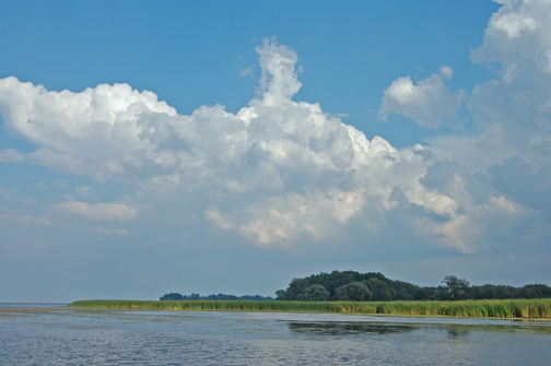
Braddock Bay and Salmon Creek are located along the southern shore of Lake Ontario, approximately eight miles northwest of the City of Rochester. This approximate 5,000 acre fish and wildlife habitat is within the Towns of Greece and Parma, Monroe County (7.5' Quadrangles: Braddock Heights, N.Y.; and Hilton, N.Y.). The Braddock Bay and Salmon Creek area consists of large, shallow, open water areas (including Braddock Bay, Cranberry Pond, Long Pond, Buck Pond, and Round Pond), extensive freshwater wetlands (predominantly emergent marsh and submergent aquatic beds), forested and open upland areas, and approximately eight miles of Salmon Creek. Salmon Creek is a relatively large, medium gradient, warmwater stream, which drains approximately 70 square miles of relatively flat agricultural and rural residential lands. The habitat includes the segment of Salmon Creek from Braddock Bay to the Parma Center Road Dam, approximately two and one-half miles southwest of the Village of Hilton. The habitat includes all of the Braddock Bay Fish and Wildlife Management area which is jointly administered by the Town of Greece and the New York State Department of Environmental Conservation based on a management plan prepared in 1981 by the DEC. The Management Plan addresses the establishment of additional acreage of nesting cover for waterfowl, the protection of critical spawning habitats for pan and game fish and the enhancement of habitat for indigenous wildlife species. In addition, the plan calls for increased public use in the form of hunting, trapping, fishing, boating, bird watching, nature study and conservation education consistent with the overall objectives of the plan.
FISH AND WILDLIFE VALUES: [SC - Species of Concern]
Braddock Bay and Salmon Creek comprise one of the largest and most important coastal freshwater wetland complexes in New York State. This area supports large concentrations of many fish and wildlife species, and provides outstanding opportunities for human use of these resources.
Throughout the year, Braddock Bay is a major concentration area for many species of migratory birds. From late winter through early spring, large concentrations of waterfowl congregate in the bays, including such species as canvasback, redhead, greater scaup, and Canada goose. Northern harriers (T), rough-legged hawks, short-eared owls (SC), and snowy owls commonly winter in the bay area. Probable or confirmed nesting species at Braddock Bay include green-backed heron, northern harrier, black tern (SC), least bittern (SC), American bittern, sedge wren (SC), Henslow's sparrow (SC), grasshopper sparrow (SC), eastern bluebird (SC), mallard, blue-winged teal, wood duck, Virginia rail, sora, common moorhen, and marsh wren. The abundance and diversity of breeding birds in this area is rare in the Great Lakes Plain ecological region. Extremely large numbers of hawks, herons, waterfowl, shorebirds, warblers, and other birds pass through the area during their spring and fall migrations. Approximately 60,000 raptors were observed moving through the Braddock Bay area during the spring of l984 and 70,000 raptors during 1985, including bald eagle (E), golden eagle (E), and osprey (T).
Other fish and wildlife species found in Braddock Bay and Salmon Creek include muskrat, mink, and raccoon. These species are important for recreational trapping by local residents. Also found here are Jefferson salmander (SC) and spotted salamander (SC). A very diverse fishery exists in Braddock Bay and Salmon Creek. Warmwater fish species present include white sucker, smallmouth bass, largemouth bass, white perch, and brown bullhead. The bay provides one of the few areas on western Lake Ontario where northern pike and largemouth bass spawn. Coldwater fish species found in the bay and in Salmon Creek include chinook and coho salmon, brown trout, and steelhead (lake-run rainbow trout). These salmonids migrate into Salmon Creek to spawn (although unsuccessfully in most instances) between late August and December. In addition, steelhead migrate into the creek again between late February and April. Seasonal runs of salmonids occur as far inland as Parma Center Road dam, which is the first impassable barrier to fish. Salmonid concentrations in Salmon Creek are the result of an ongoing effort by the NYSDEC to restore the Great Lakes salmonid fishery through stocking. Approximately 10,000 steelhead were stocked in the creek in l984, and chinook salmon may be reproducing naturally in the creek.
Recreational opportunities available in Braddock Bay and Salmon Creek include birdwatching, trapping, waterfowl hunting, and fishing. Braddock Bay is a major spring hawk-watching and year-round birdwatching area in western New York. The Wildlife Management Area provides easy access for people to use the fish and wildlife resources. Anglers from throughout the Rochester metropolitan area are attracted to the salmonid fisheries in Salmon Creek. Braddock Bay provides a productive warmwater fishery, but is more often used as a motorboat access site for fishing in Lake Ontario.
IMPACT ASSESSMENT:
A habitat impairment test must be met for any activity that is subject to consistency review under federal and State laws, or under applicable local laws contained in an approved local waterfront revitalization program. If the proposed action is subject to consistency review, then the habitat protection policy applies, whether the proposed action is to occur within or outside the designated area.
The specific habitat impairment test that must be met is as follows:
in order to protect and preserve a significant habitat, land and water uses or development
shall not be undertaken if such actions would: destroy the habitat; or, significantly impair the viability of a habitat.
Habitat destruction is defined as the loss of fish or wildlife use through direct physical alteration, disturbance, or pollution of a designated area or through the indirect effects of these actions on a designated area. Habitat destruction may be indicated by changes in vegetation, substrate, or hydrology, or increases in runoff, erosion, sedimentation, or pollutants.
Significant impairment is defined as reduction in vital resources (e.g., food, shelter, living space) or change in environmental conditions (e.g., temperature, substrate, salinity) beyond the tolerance range of an organism. Indicators of a significantly impaired habitat focus on ecological alterations and may include but are not limited to reduced carrying capacity, changes in community structure (food chain relationships, species diversity), reduced productivity and/or increased incidence of disease and mortality.
The tolerance range of an organism is not defined as the physiological range of conditions beyond which a species will not survive at all, but as the ecological range of conditions that supports the species population or has the potential to support a restored population, where practical.
Either the loss of individuals through an increase in emigration or an increase in death rate indicates that the tolerance range of an organism has been exceeded. An abrupt increase in death rate may occur as an environmental factor falls beyond a tolerance limit (a range has both upper and lower limits). Many environmental factors, however, do not have a sharply defined tolerance limit, but produce increasing emigration or death rates with increasing departure from conditions that are optimal for the species.
The range of parameters which should be considered in applying the habitat impairment test include but are not limited to the following:
1. physical parameters such as living space, circulation, flushing rates, tidal amplitude, turbidity, water temperature, depth (including loss of littoral zone), morphology, substrate type, vegetation, structure, erosion and sedimentation rates;
2. biological parameters such as community structure, food chain relationships, species diversity, predator/prey relationships, population size, mortality rates, reproductive rates, meristic features, behavioral patterns and migratory patterns; and,
3. chemical parameters such as dissolved oxygen, carbon dioxide, acidity, dissolved solids, nutrients, organics, salinity, and pollutants (heavy metals, toxics and hazardous materials).
Although not comprehensive, examples of generic activities and impacts which could destroy significantly impair the habitat are listed below to assist in applying the habitat impairment test to a proposed activity.
Any activity that degrades water quality, increases temperature or turbidity, reduces flows, or alters water levels in the Braddock Bay and Salmon Creek area would adversely affect many fish and wildlife species. Discharges of sewage or stormwater runoff containing sediments or chemical pollutants could result in adverse impacts on fish and wildlife resources of the area. Elimination of wetland vegetation, including submergent beds, through dredging, filling, or bulkheading, would result in a direct loss of valuable habitat area.
However, habitat management activities, including water level management, can be designed to maintain or enhance populations of certain species of fish or wildlife. Habitat disturbances would be most detrimental during fish spawning and incubation periods (late February - July for steelhead and most warmwater species, and September - November for most salmonids) and wildlife breeding seasons (April - July for most species).
Barriers to fish migration, whether physical or chemical, would have a significant effect on salmonid populations in Salmon Creek. Public access to Braddock Bay and Salmon Creek should be maintained or enhanced to ensure that adequate opportunities are available for compatible human uses of the fish and wildlife resources.
However, development of additional motorboat access to Lake Ontario from Braddock Bay could adversely affect the value of this area to migratory birds and resident fish populations, through boating impacts or inducement of further waterfront development on private lands.
Development of shoreline areas could have significant impacts on fish and wildlife, through elimination or disturbance of productive wetland areas and littoral zones, and through pollution (e.g., sedimentation) of the bays from upland activities. Undisturbed areas of natural vegetation bordering Braddock Bay and Salmon Creek should be maintained to provide cover for wildlife, soil stabilization, and buffer zones. The continued implementation of the Braddock Bay Fish and Wildlife Management Plan by the Town of Greece and the DEC will help ensure the enhancement of the complex for fish, wildlife and public access.
