CRRA includes two key provisions to advance New York's adaptation to climate change:
Applicants to certain State programs must demonstrate that they have taken into account future physical climate risks caused by storm surges, sea-level rise or flooding.
By January 1, 2016, DEC must establish in regulation State-adopted sea-level rise projections, which will be used as the basis for State adaptation decisions and will be available for use by all decision makers.
CRRA applies to specific State permitting, funding and regulatory decisions, including smart growth assessments; funding for wastewater treatment plants; siting of hazardous waste facilities; design and construction of petroleum and chemical bulk storage facilities; oil and gas drilling, and State acquisition of open space.
DEC has drafted the proposed regulation that establishes sea-level rise projections (6 NYCRR Part 490). Five public information and listening meetings were held over the summer of 2015 regarding the proposed sea-level rise regulation. The rulemaking process is currently underway and the proposed sea-level rise regulation is available for formal public comment through December 28, 2015.
See the following sea-level rise projections resources:
CRRA requires DEC to develop implementation guidance by January 1, 2017. This guidance will describe application requirements for applicants in programs covered by CRRA and review procedures for agency staff. DEC has begun developing this guidance and has initiated a process to inform interested stakeholders of progress and provide opportunities for stakeholder input. DEC hosted the first CRRA public stakeholder update meeting on November 16, 2015 (meeting information is provided below). Additional opportunities will be provided in 2016. To receive information on these opportunities, subscribe to "Climate Change Information" through DEC DELIVERS.
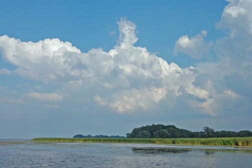
COASTAL FISH &
WILDLIFE HABITAT RATING FORM Name of Area: Braddock
Bay and Salmon Creek Designated: October 15, 1987
County: Monroe
Town(s): Greece, Parma 71⁄2'
Quadrangle(s): Braddock Heights, NY; Hilton, NY Score Criterion
64 Ecosystem Rarity (ER) One of the largest
coastal wetland ecosystems in New York State. 40 Species
Vulnerability (SV)
Northern harrier (T), black tern (SC), least bittern (SC), sedge wren (SC),
spotted salamander (SC) and Jefferson salamander (SC).
Additive division: 25 + 16/2 + 16/4 + 16/8 + 16/16 30 Human Use (HU)
A valuable site for observation of migratory birds on the northeastern United
States; fishing and waterfowl hunting attract recreational users from
throughout the Genesee Valley. Additive division: 25 + 9/2 9 Population Level
(PL)
One of the major concentration areas for migratory birds in the Great Lakes
coastal region. Replaceability (R)
1.2 Irreplaceable SIGNIFICANCE VALUE
= [( ER + SV + HU + PL ) X R] = 171 DESIGNATED
HABITAT: BRADDOCK BAY AND SALMON CREEK LOCATION AND
DESCRIPTION OF HABITAT: Braddock Bay and
Salmon Creek are located along the southern shore of Lake Ontario,
approximately eight miles northwest of the City of Rochester. This approximate
5,000 acre fish and wildlife habitat is within the Towns of Greece and Parma,
Monroe County (7.5' Quadrangles: Braddock Heights, N.Y.; and Hilton, N.Y.). The
Braddock Bay and Salmon Creek area consists of large, shallow, open water areas
(including Braddock Bay, Cranberry Pond, Long Pond, Buck Pond, and Round Pond),
extensive freshwater wetlands (predominantly emergent marsh and submergent
aquatic beds), forested and open upland areas, and approximately eight miles of
Salmon Creek. Salmon Creek is a relatively large, medium gradient, warmwater
stream, which drains approximately 70 square miles of relatively flat
agricultural and rural residential lands. The habitat includes the segment of
Salmon Creek from Braddock Bay to the Parma Center Road Dam, approximately two
and one-half miles southwest of the Village of Hilton. The habitat includes all
of the Braddock Bay Fish and Wildlife Management area which is jointly
administered by the Town of Greece and the New York State Department of
Environmental Conservation based on a management plan prepared in 1981 by the DEC.
The Management Plan addresses the establishment of additional acreage of
nesting cover for waterfowl, the protection of critical spawning habitats for
pan and game fish and the enhancement of habitat for indigenous wildlife
species. In addition, the plan calls for increased public use in the form of
hunting, trapping, fishing, boating, bird watching, nature study and
conservation education consistent with the overall objectives of the plan. FISH AND WILDLIFE
VALUES: [SC - Species of Concern] Braddock Bay and
Salmon Creek comprise one of the largest and most important coastal freshwater
wetland complexes in New York State. This area supports large concentrations of
many fish and wildlife species, and provides outstanding opportunities for
human use of these resources. Throughout the
year, Braddock Bay is a major concentration area for many species of migratory
birds. From late winter through early spring, large concentrations of waterfowl
congregate in the bays, including such species as canvasback, redhead, greater
scaup, and Canada goose. Northern harriers (T), rough-legged hawks, short-eared
owls (SC), and snowy owls commonly winter in the bay area. Probable or
confirmed nesting species at Braddock Bay include green-backed heron, northern
harrier, black tern (SC), least bittern (SC), American bittern, sedge wren
(SC), Henslow's sparrow (SC), grasshopper sparrow (SC), eastern bluebird (SC),
mallard, blue-winged teal, wood duck, Virginia rail, sora, common moorhen, and
marsh wren. The abundance and diversity of breeding birds in this area is rare
in the Great Lakes Plain ecological region. Extremely large numbers of hawks,
herons, waterfowl, shorebirds, warblers, and other birds pass through the area
during their spring and fall migrations. Approximately 60,000 raptors were
observed moving through the Braddock Bay area during the spring of l984 and
70,000 raptors during 1985, including bald eagle (E), golden eagle (E), and
osprey (T). Other fish and
wildlife species found in Braddock Bay and Salmon Creek include muskrat, mink,
and raccoon. These species are important for recreational trapping by local
residents. Also found here are Jefferson salmander (SC) and spotted salamander
(SC). A very diverse fishery exists in Braddock Bay and Salmon Creek. Warmwater
fish species present include white sucker, smallmouth bass, largemouth bass,
white perch, and brown bullhead. The bay provides one of the few areas on
western Lake Ontario where northern pike and largemouth bass spawn. Coldwater
fish species found in the bay and in Salmon Creek include chinook and coho
salmon, brown trout, and steelhead (lake-run rainbow trout). These salmonids
migrate into Salmon Creek to spawn (although unsuccessfully in most instances)
between late August and December. In addition, steelhead migrate into the creek
again between late February and April. Seasonal runs of salmonids occur as far
inland as Parma Center Road dam, which is the first impassable barrier to fish. Salmonid
concentrations in Salmon Creek are the result of an ongoing effort by the
NYSDEC to restore the Great Lakes salmonid fishery through stocking.
Approximately 10,000 steelhead were stocked in the creek in l984, and chinook
salmon may be reproducing naturally in the creek. Recreational
opportunities available in Braddock Bay and Salmon Creek include birdwatching,
trapping, waterfowl hunting, and fishing. Braddock Bay is a major spring
hawk-watching and year-round birdwatching area in western New York. The
Wildlife Management Area provides easy access for people to use the fish and
wildlife resources. Anglers from throughout the Rochester metropolitan area are
attracted to the salmonid fisheries in Salmon Creek. Braddock Bay provides a
productive warmwater fishery, but is more often used as a motorboat access site
for fishing in Lake Ontario. IMPACT ASSESSMENT: A habitat
impairment test must be met for any activity that is subject to consistency
review under federal and State laws, or under applicable local laws contained
in an approved local waterfront revitalization program. If the proposed action
is subject to consistency review, then the habitat protection policy applies,
whether the proposed action is to occur within or outside the designated area. The specific habitat
impairment test that must be met is as follows: in order to protect and preserve a significant habitat, land and water uses or
development shall not be
undertaken if such actions would: destroy the habitat; or, significantly impair the viability of a habitat. Habitat
destruction is defined as the loss of fish or wildlife use through direct
physical alteration, disturbance, or pollution of a designated area or through
the indirect effects of these actions on a designated area. Habitat destruction
may be indicated by changes in vegetation, substrate, or hydrology, or increases
in runoff, erosion, sedimentation, or pollutants. Significant
impairment is defined as reduction in vital resources (e.g., food, shelter,
living space) or change in environmental conditions (e.g., temperature,
substrate, salinity) beyond the tolerance range of an organism. Indicators of a
significantly impaired habitat focus on ecological alterations and may include
but are not limited to reduced carrying capacity, changes in community
structure (food chain relationships, species diversity), reduced productivity
and/or increased incidence of disease and mortality. The tolerance
range of an organism is not defined as the physiological range of conditions
beyond which a species will not survive at all, but as the ecological range of
conditions that supports the species population or has the potential to support
a restored population, where practical. Either the loss of individuals through
an increase in emigration or an increase in death rate indicates that the
tolerance range of an organism has been exceeded. An abrupt increase in death
rate may occur as an environmental factor falls beyond a tolerance limit (a
range has both upper and lower limits). Many environmental factors, however, do
not have a sharply defined tolerance limit, but produce increasing emigration
or death rates with increasing departure from conditions that are optimal for
the species. The range of
parameters which should be considered in applying the habitat impairment test
include but are not limited to the following: 1. physical
parameters such as living space, circulation, flushing rates, tidal amplitude,
turbidity, watertemperature, depth
(including loss of littoral zone), morphology, substrate type, vegetation,
structure,erosion and
sedimentation rates; 2.biological
parameters such as community structure, food chain relationships, species
diversity, predator/prey
relationships, population size, mortality rates, reproductive rates, meristic
features, behavioral
patterns and migratory patterns; and, 3.chemical
parameters such as dissolved oxygen, carbon dioxide, acidity, dissolved solids,
nutrients, organics,
salinity, and pollutants (heavy metals, toxics and hazardous materials). Although not comprehensive, examples of generic activities and impacts which could destroy significantly impair the habitat are listed below to assist in applying the habitat
impairment test to a proposed activity. Any activity that
degrades water quality, increases temperature or turbidity, reduces flows, or
alters water levels in the Braddock Bay and Salmon Creek area would adversely
affect many fish and wildlife species. Discharges of sewage or stormwater
runoff containing sediments or chemical pollutants could result in adverse impacts
on fish and wildlife resources of the area. Elimination of wetland vegetation,
including submergent beds, through dredging, filling, or bulkheading, would
result in a direct loss of valuable habitat area. However, habitat management
activities, including water level management, can be designed to maintain or
enhance populations of certain species of fish or wildlife. Habitat
disturbances would be most detrimental during fish spawning and incubation
periods (late February - July for steelhead and most warmwater species, and
September - November for most salmonids) and wildlife breeding seasons (April -
July for most species). Barriers to fish migration, whether physical or
chemical, would have a significant effect on salmonid populations in Salmon
Creek. Public access to Braddock Bay and Salmon Creek should be maintained or
enhanced to ensure that adequate opportunities are available for compatible
human uses of the fish and wildlife resources. However, development of
additional motorboat access to Lake Ontario from Braddock Bay could adversely
affect the value of this area to migratory birds and resident fish populations,
through boating impacts or inducement of further waterfront development on
private lands. Development of shoreline areas could have significant impacts on
fish and wildlife, through elimination or disturbance of productive wetland
areas and littoral zones, and through pollution (e.g., sedimentation) of the
bays from upland activities. Undisturbed areas of natural vegetation bordering
Braddock Bay and Salmon Creek should be maintained to provide cover for
wildlife, soil stabilization, and buffer zones. The continued implementation of
the Braddock Bay Fish and Wildlife Management Plan by the Town of Greece and
the DEC will help ensure the enhancement of the complex for fish, wildlife and
public access.
The New York State Department of Environmental Conservation and the Monroe County Department of Public Health are holding a presentation on the Rochester Embayment "Area of Concern" on Tuesday, November 17, 2015 at 7 pm, at the Roger Robach Community Center, 180 Beach Ave., Rochester NY, 14612. It has been designed, i.e. receives several funding streams from state and federal sources, as an 'Area of Concern' by the NYS DEC. "The purpose of this meeting is to provide an update on several previously noted environmental issues in our Embayment. We hope you can join us and provide input into this important environmental matter."
News Release Nov. 10, 2015
from Monroe County Sanitarian, Pete Rightmyer:
The New York State Department of Environmental
Conservation and the Monroe County Department of Public Health will host a
public meeting at 7 pm on November 17, 2015, at the
Roger Robach Community Center, 180 Beach Avenue, to discuss
improvements in the environmental quality of the Rochester Embayment.
In 1987, the Rochester
Embayment was designated as an Area of Concern (AOC) by the U.S.-Canada
Great Lakes Water Quality Agreement, indicating that it is a location that
has experienced environmental degradation.
The Monroe County Department
of Public Health, together with many valued partners, has lead an initiative
for many years known as the Remedial Action Plan (RAP) process to address
identified environmental concerns.
“Achieving progress in
the identified environmental problem areas requires the work of many, and
doesn’t happen quickly. We’re eager to update the community on our most recent
progress,” said Dr. Jeremy Cushman, Interim Public Health
Commissioner.
“Thanks
to federal, state and local collaboration and resources, the Rochester
Embayment is an important waterway on the road to recovery. Input from the
public and our partnering stakeholders has been a critical component of these
efforts and DEC encourages the public’s continued participation in the
restoration of this incredible resource,” said NYS DEC Acting
Commissioner Basil Seggos.
The Rochester
Embayment AOC is an area formed by the indentation of the Monroe County
shoreline between Bogus Point in the town of Parma and Nine Mile Point in the
town of Webster. The southern boundary includes approximately 6
miles of the Genesee River that is influenced by lake levels, from the river's
mouth to the Lower Falls.
The RAP identified 14
impairments for the AOC. Impairments included items such as
degradation of fish and wildlife populations, restrictions on dredging, and
aesthetics. Each impairment has associated criteria that must be met
in order for it to be removed from the list. Upon the completion
of remedial actions for all impairments, the Rochester Embayment will be
recommended for a status update from an Area of Concern to an Area in
Recovery. Health and
environmental officials are also seeking input via e-mail from individuals who
may not be able to make it to a meeting but want to stay informed, receive
updates, and obtain documents to review. To be placed on this list,
residents should send an e-mail
to wadesilkworth@monroecounty.gov with the subject “RAP” and a
message containing your full name, e-mail address, and town of residence.
Supports project activities such as dam and barrier removal implementation, design, and project viability analysis.
Aims to improve public safety and encourage economic growth, while restoring the natural form and function of the river or stream.
Provides technical guidance, including assistance with environmental compliance and monitoring.
In the United States, millions of dams and other barriers block fish from reaching upstream spawning and rearing habitat. Dams often provide benefits, such as hydroelectric power and irrigation, but many are now obsolete. Removing these structures can improve the health of our rivers, fisheries, and our economy.
In 2005, NOAA created the Open Rivers Initiative, which provides communities with funding and technical guidance to carry out dam and barrier removal projects that restore local rivers and streams. The initiative is focused on community-driven dam and river barrier removals, with the goal of enhancing watershed health and fostering sustainable populations of migratory fish such as salmon, sturgeon, shad, river herring, and American eel. For more: http://www.habitat.noaa.gov/restoration/programs/ori.html
Town of Greece 1 Vince Tofany Blvd Rochester, NY 14612
Facility:
Braddock Bay Braddock Bay @ Lake Ontario Pkwy Greece, NY
Application ID:
8-2628-00820/00002
Permit(s) Applied for:
Article 15 Title 5 Excavation & Fill in Navigable Waters Article 24 Freshwater Wetlands Section 401 - Clean Water Act Water Quality Certification
Project is Located:
Greece, Monroe County
Project Description:
The Town of Greece is proposing a wetland protection and restoration project aimed at restoring wetland and habitat diversity in Braddock Bay and providing erosion protection to the remaining wetlands. The project would include the construction of a new headland beach breakwater structure measuring approximately 1,695 linear feet (LF) in length, including approximately 1,000 LF of headland beach, two 150 LF rubblemound breakwaters and two 180 LF terminal groins. The headland beach would be filled with borrowed sand from the bay mouth and courser sand that would be trucked in. The project also seeks to restore and enhance approximately 8.89 acres of wetland including the restoration of 3 acres of eroded wetland, the excavation of channels and potholes through the cattail marsh, and the mechanical and chemical control of invasive species. The project has been designed by the US Army Corps of Engineers and is/would be funded through the US Environmental Protection Agency (EPA) under the Great Lakes Restoration Initiative (GLRI). Additionally, the proposed work will occur on lands owned by New York State and under the management of the NYS Department of Environmental Conservation and NYS Parks, Recreation and Historic Preservation. Further information related to the proposed Braddock Bay project can be found at http://www.lrb.usace.army.mil/Missions/CivilWorks/DistrictProjects/BraddockBay.aspx or by viewing the permit application file at the NYSDEC Region 8 office in Avon, NY.
Availability of Application Documents:
Filed application documents, and Department draft permits where applicable, are available for inspection during normal business hours at the address of the contact person. To ensure timely service at the time of inspection, it is recommended that an appointment be made with the contact person.
State Environmental Quality Review (SEQR) Determination:
Project is a Type I action and will not have a significant effect on the environment. A coordinated review with other agencies was performed and a Negative Declaration is on file.
SEQR Lead Agency: Greece Town Board
State Historic Preservation Act (SHPA) Determination:
A cultural resources survey has been completed. Based on information provided in the survey report, the New York State Office of Parks, Recreation and Historic Preservation (OPRHP) has determined that the proposed activity will have no impact on registered or eligible archaeological sites or historic structures. No further review in accordance with SHPA is required.
Coastal Management:
This project is located in a Coastal Management area and is subject to the Waterfront Revitalization and Coastal Resources Act.
Opportunity for Public Comment:
Comments on this project must be submitted in writing to the Contact Person no later than Jun 18, 2015.
Contact:
Thomas P Haley NYSDEC Region 8 Headquarters 6274 E Avon-Lima Rd Avon, NY 14414 (585)226-2466 DEP.R8@dec.ny.gov
After reading that the EPA funded the Town of Greece [via US Army Corps as interagency] desire to remake the character of Braddock Bay in the name of 'restoration,' I thought it time I state my feelings as a resident of Manitou Beach Rd.
Sandy Creek Ponds and Barrier Beach located in northern Oswego County
New York on eastern Lake Ontario
I just got back from the eastern Lake Ontario area - Sandy Creek ponds north and south, an area that was once very popular -- especially when fishing was king in the 1940s-50s. Today it feels like a jumble of vintage trailers, rickety cottages and mishmash shoreline development so very very different from Monroe County. The shoreline of northern Oswego County could have been a pristine barrier beach [almost as great as Fire Island] region but today it is a hodgepodge of no-zoning/planning and a zillion docks on every inch of marshland, creek and river. I see Southpoint Marina on the south end of Irondequoit Bay working to restore a marina. That's exactly what the Town of the Greece wants to do to the Braddock Bay Marina -- not to mention the marina project at the Rochester Harbor. That's what all this ruse about 'restoration' is about -- a way to keep a channel dredged to build back the boating in the area. Too little too late is the DEC's Natural Heritage Designation for Eastern Lake Ontario. When I see the big mess the eastern shoreline of Lake Ontario is in Jefferson County, I am actually shocked. Take the oldest and smallest cottage on Edgemere Drive and multiply that by 10,000 - that's the ruin of the shoreline. I wish the US Army Corps would take the concrete headland away from the project, but I don't think that will happen. I envision another engineered attempt to take a protected State Wildlife Management Area and turn it into a marina. Period. I think the Braddock Bay status as Audubon Important Bird Area and all the bird organizations, etc. should have had more effect on the decision-making process, but unfortunately the birders caved to the Town's wishes for reasons I can only surmise -- funds to remove invasives and public relations for them. I believe that much of the funding for 'restoration' is in the name of preventing shoreline erosion after the super-storm Sandy hit NYS. There are a lot of little cottages that are going in the water in the next 50 years. Let's see what occurs . . . . we don't have the last word. Water has the last say.
In the past decade, freshwater and sediment diverted from the Mississippi River have turned what once was an open bay into a thriving wetlands area. Local environmental groups have planted thousands of cypress trees, attempting to create a marsh that will help absorb storms that pass through.
Weenta Girmay for WWNO
In a lush green bayou a little southeast of New Orleans, John Lopez and Howard Callahan are cruising the waterways in an airboat under the hot Louisiana sun on a recent day.
It's an area known as Breton Basin, and Callahan is a local land manager who often helps researchers such as Lopez explore environmental changes in coastal wetlands. The pair head to a concrete and steel structure that separates the bayou from the nearby Mississippi River.
This is the Caernarvon river diversion. Built in 1991, it works like a faucet: When it's open, freshwater and sediment from the Mississippi River — usually hemmed in by the levee system — flow back into what was a dying swamp. Diversions such as this one are meant to free the river to do its original job as it nears the Gulf of Mexico: spread out sediment, create land and provide freshwater to local habitats.
In the past decade, thick, green vegetation has grown up around the diversion, and Lopez says that's a good thing.
"This is what Louisiana's supposed to be," he says. "Not a dying coast, but a living coast."
John Lopez, director of coastal sustainability for the Lake Pontchartrain Basin Foundation, looks out at the Caernarvon river diversion. The structure diverts freshwater from the Mississippi River into the Breton Basin, helping to restore a balance with saltwater from the Gulf of Mexico.
Weenta Girmay for WWNO
Now, 10 years after Hurricane Katrina devastated much of the Gulf Coast region, expanded efforts are underway to revitalize this "living coast," Louisiana's original storm protection system. State officials have earmarked billions of dollars to rebuild the marshes and wetlands that create a natural buffer against storms and floods.
Over the past century, man-made canals and natural storm surge pushed too much saltwater into the bayou, killing the swamp. Cypress trees and swamp grasses are what slow hurricanes down and absorb storm surge.
New Orleans is technically 80 miles from the Gulf of Mexico, but with a football field of coastal wetlands disappearing every half-hour, that distance is deceptive, says Kyle Graham, head of Louisiana's Coastal Protection and Restoration Authority.
"Our levee systems aren't designed to have the Gulf of Mexico lapping up against the outside. They're designed to have that amount of marsh, or a marsh-protected fringe in between them and the Gulf of Mexico," he says.
Graham oversees an ambitious plan — $50 billion over 50 years — to rebuild the coast. Compare that to the $14 billion spent since Hurricane Katrina to rebuild the man-made levee system that lines the Mississippi River and protects the city of New Orleans and other areas along the river.
The coastal rebuilding plan prescribes bigger and deeper diversions than Caernarvon, according to the Environmental Defense Fund's Natalie Peyronnin, who helped draft the idea. The alternative — digging up sediment, transporting it and manufacturing land — is too expensive, she says.
"We know the river built the wetlands; we do know that. And we know that the river can rebuild wetlands, and they can rebuild the system on a scale that we can't mechanically do with just dredging," Peyronnin says.
Local land manager Howard Callahan navigates his airboat, which helps local environmental groups get deep into the Breton Basin area to investigate the impact of the Caernarvon river diversion.
Weenta Girmay for WWNO
Not everybody wants diversions. George Ricks is one of several sport fishermen worried about the effects of river diversions. More freshwater and less saltwater will upset the balance of local habitats that nurture fish, shrimp, oysters and more.
"When you look at the economic impact of losing our fisheries, and our seafood industries, and our restaurant businesses, because of a lack of seafood, it's not that economically feasible to have diversions instead of dredging," Ricks says.
But diversion advocates say the Gulf of Mexico will eventually push back and restore the brackish water balance. And with Louisiana's coast rapidly disappearing, there are bigger issues at hand, says Peyronnin of the Environmental Defense Fund.
"If we don't use the river to build land, and maintain this wonderful coast, then people are going to have to move away," she says.
Louisiana officials hope to begin construction of multiple river diversions in the next few years. They believe this approach will give Louisiana not just its coast back, but its best chance at surviving the next big hurricane.